
Map dating is a very well known activity, and there are tons of resources to help you do it. However, most of the time the map/globe in question covers the whole world. What about a map of Singapore?
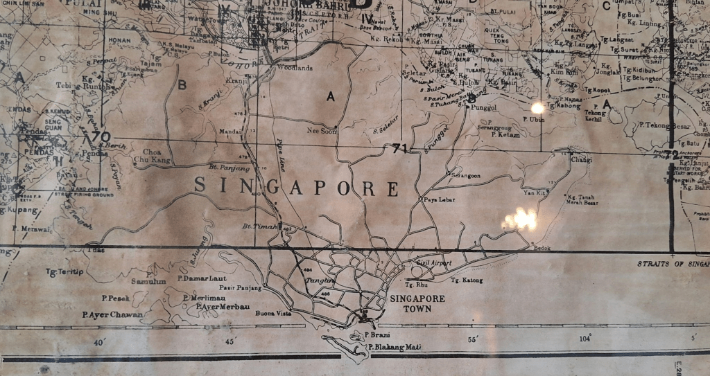
I took this picture at a café in Johor Bahru, and there was no date on it. There are a lot of familiar names, but also a lot of missing details. I’m not sure how accurately this map is drawn, so being the bored NSF I am, I’ll just list out everything that seems helpful from the 20th century (a lot of information comes from here, here, here and here).
| Event | Date |
| East Coast Road built | 1902 |
| Woodlands Railway Station opened (part of the Singapore-Kranji Railway) | April 1903 |
| Singapore-Kranji Railway extended to Pasir Panjang station | January 1907 |
| Impounding Reservoir renamed Thomson (Road) Reservoir | 1907 |
| Kallang River Reservoir opens | 1912 |
| Kallang River Reservoir renamed Pierce Reservoir | 1922 |
| Woodlands Railway Station closed | October 1923 |
| Sims Avenue opens | Feburary 1924 |
| Woodlands causeway opens | June 1924 |
| Singpaore-Johor water pipeline opens | December 1927 |
| Woodlands Road named | 1929 |
| Tanjong Pagar Railway Station opens | May 1932 |
| Time zone change from GMT+7 to GMT+7:20 | January 1933 |
| Changi Prison opened | 1936 |
| Kallang Airport (Singapore Civil Airport) opens | June 1937 |
| Singapore Naval Base opens in Sembawang | Feburary 1938 |
| Time zone change from GMT+7:20 to GMT+7:30 | September 1941 |
| Japanese occupation (also time zone change to GMT+9) | February 1942 |
| Singapore falls under the British Military Administration of Malaya | August 1945 |
| Singapore becomes a separate crown colony, no longer part of the Straits Settlements | April 1946 |
| Grove Road renamed Mountbatten Road | August 1946 |
| Reformatory Road renamed Clementi Road | 1947 |
| Pulau Serangoon renamed Coney Island | 1950 |
| Shenton Way opens | August 1951 |
| Singapore International Airport (Paya Lebar Airport) opens | June 1955 |
| Nicoll Highway completed | August 1956 |
| Upper Bukit Timah Road & Upper Thomson Road renamed | April 1959 |
| Upper Jurong Road renamed | 1961 |
| Boon Lay Road renamed Jalan Boon Lay | 1964 |
| Jurong Railway Station opened | November 1965 |
| PIE Phase 1 opens (Paya Lebar – Whitley Road) | May 1966 |
| Jalan Bahru Selatan (now Jurong Town Hall Road) built | 1969 |
| Pulau Blakang Mati renamed Sentosa | September 1970 |
| Sungei Jurong dammed (Jurong Lake formed) | 1971 |
| Marine Parade reclaimed (southeast coastline is straight) | 1972 |
| Sungei Pandan dammed (Pandan Reservoir formed) | 1974 |
| ECP Phase 1 opens (Marine Parade – Fort Road) | December 1974 |
| Sungei Kranji dammed (Kranji reservoir opens) | 1975 |
| ECP Phase 2 opens (Marine Parade – Bedok South) | February 1976 |
| PIE Phase 2 opens (Adam Road – Upper Bukit Timah Road) | September 1976 |
| Pulau Tekong reservoir completed | September 1979 |
| ECP Phase 3 opens (Bedok – Changi) | January 1980 |
| ECP Phase 4 opens (Fort Road – Keppel Road) | April 1981 |
| Western water catchment completed | July 1981 |
| Sungei Seletar dammed (Yishun dam) | April 1984 |
| Southern Islands Live Firing Area created | November 1984 |
| Bedok reservoir completed | July 1985 |
| BKE opens | January 1986 |
| Tuas reclamation works start | 1986 |
| CTE completed | September 1991 |
| Marina Bay reclaimed | 1992 |
| Sentosa Causeway opened | December 1992 |
| PIE completed (Jurong Road – Upper Jurong Road) | December 1993 |
| KJE opens | February 1994 |
| Tuas Second Link opens | January 1998 |
| Jurong Island connected | 1998 |
| Semakau landfill becomes operational | April 1999 |
What can we say about the map of Singapore above? Honestly, it was still very difficult to find a good range of years, mostly because all the roads weren’t labelled. An extremely conservative range would be 1937-1955, the years in which Kallang airport was operational. We can drop the lower bound to 1951 because this island was labelled Pulau Seranggong instead of Coney Island.
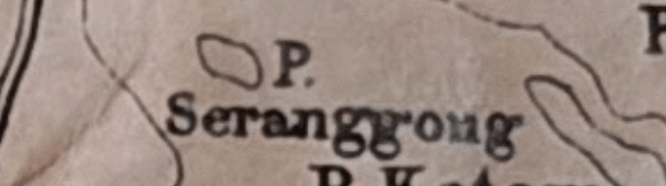
The takeover and renaming of the island as Singapore’s newest tourist attraction was well-publicised, and there were even many events taking place there. 1937-1951 is thus a very reasonable bet.
A 14 year range is still too wide though. Is it possible to tell if this map was from pre- or post-WW2? As it turns out, we can – with the help of a random line of text on the west coast:
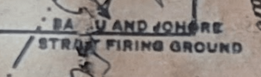
This firing ground was only announced in December 1946. You may check here that no mention of this has been made in local newspapers before. Thus, our map comes from December 1946 – March 1951, and I’m satisfied with this <5 year range.
Can we do even better? I’m not so sure – perhaps some of the Johor bits may help. I’ll leave it as an exercise to the reader.
Thanks for reading!
While researching for the table above, I’ve learnt a lot about random events in Singapore’s history. Honestly, what surprised me most is that most of the place names we have today already exist in the 1850s, and some even before the British arrival. The same is true for non-central roads such as Mandai Road (1855), Jurong Road (1853), Pasir Panjang road (1850), and Changi Road (1845). This meant that all the different kampongs around the island were already connected to each other 170 years ago.
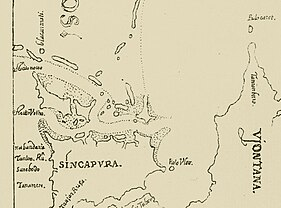
In fact, in this 1604 (!) map of Singapore by Bugis-Portugese cartographer Manuel Godinho de Erédia, we can already see the names Tanah Merah, Tanjong Rhu, Bedok, Changi, and more.
Here are 5 more random memorable facts:
1. A snippet from the Wikipedia article for Mount Faber:
Faber cut through the thick undergrowth, allowing the road to the top of the hill to be built. The original winding road was referred to in the press at that time as a “stupidly narrow road”.
[…] A signal station was erected on the hill in 1845. This signal station was transferred from Pulau Blakang Mati (now Sentosa) because of the “injurious miasma” on the island.
2. In the past (before 1970), main roads in Singapore were often depicted as a rooted “tree” from the General Post Office, and there were physical mile-stones that people used to describe their location.
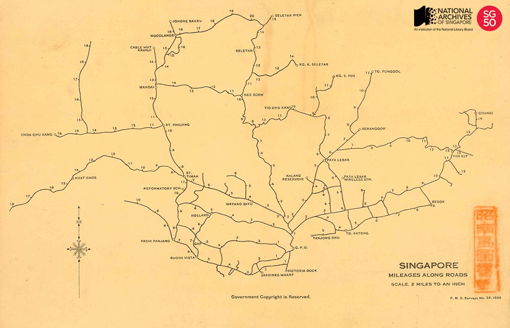
It was common up to the 1960s for people to refer to places by milestone along a particular road, for example 7 Milestone Bukit Timah Road or 5 ½ Milestone Changi Road.
3. There was a mutiny in Singapore! 4 companies decided to blockade their CO’s bungalow, which is hilarious.
4. You can actually see some parts of the pipes that bring water in from Malaysia to Singapore.
5. Singapore has changed its time zone 6 times. Apparently, one of them was for daylight savings.

Leave a comment